During my last visit, I came across several piles of rocks that I believe were stone prayers. Stone Prayers are piles of stones placed on one or more boulders. They can consist of a few stones without any real design or can be quite elaborate with many stones. I found examples of both of these in this preserve.
The first picture is of a simple stone prayer; this one was a small rectangle and on three base stones. I don’t disturb these stones so if there’s a lot of debris on or around the stones I have to guess on what the base is like.
The second picture is another example of a stone prayer, this one rectangular. If you watch my video on the first trip you will see a great example of one placed in the crotch of two boulders. When you come upon stone prayers, you can see the stones were intentionally placed as these were.
In addition to the stone prayers, there were numerous stone piles. The difference between a stone pile and a stone prayer is that the stones in the stone pile are more random in their placement. They are also found on the ground and not on boulders. This picture is interesting as it may also be a stone enclosure. Notice the bottom right of the picture, and you will see a triangular enclosure.
Although in my opinion, this was enough to confirm that this was a CSL, I did find more evidence. I came across a stone cairn. A stone cairn is defined as a carefully constructed stone structure built directly on the ground. When you see these, there’s no doubt they are manmade. You can see the cairn in the video.
Unfortunatel of y I did not take a still picture of it. It is about four feet high and rectangular in shape, about 4 feet long and three feet wide. This cairn is very similar to one I found at another location. This picture is of the one I found at another location. When I post the video for this explore, you can compare the two.
Throughout this area, there were many stone walls. These were very well built. They were between two and four feet tall, with some of them built in a serpentine shape. Sometimes walls are fallen down. For example, if hunters come through the area, they may knock them down. If this were the case the rocks would be on the ground near the wall. There are none here.
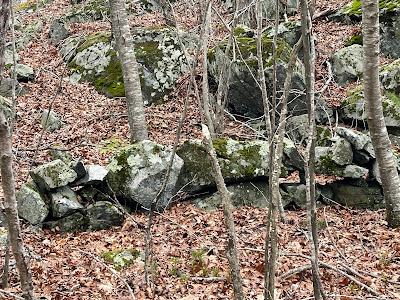
Some of these walls were quite lengthy and were connected to others. Some were very short with no connection to the rest of them. One of the characteristics of Native American stone rows is that they have certain architectural elements to them, such as a large stone surrounded by smaller stones, as in the picture below. This also is a short section with no connection to any other.
The ends of the walls tend not to be “finished”. This means they aren’t straight up and down; rather they have either a larger stone as the end or a length of smaller stones that resemble a tail. These stone rows are often effigies, serpents, turtles and snakes are the most common.
I also came across two stone enclosures, one circular and one trapezoid-shaped. There was also one square made of stone walls that may have been used to hold livestock, however, there was no opening. I also found no evidence of any foundations except one possible house cellar that I will describe later.
I also found some other interesting features in this location, neither of which I believe are Native American related. I came across four hand-dug holes, each about the same size. They were about four feet deep and about five feet long and three feet wide. The picture below is of one of these holes. The dirt pile is to the right.
They were not lined with stones, so I don’t believe they were foundations for any kind of building. The evidence leads me to conclude they were dug by hand. Each had a dirt pile next to them that was most likely the soil from the hole. I did not mark the locations of them, but they were not close to one another, leading me to believe they weren’t outbuildings of a farm.
The final and most interesting find, although probably not Native American, was a large tree that had grown through a large flat rock.
These two pictures show a tree growing through a flat rock, splitting the rock. You can see that before the tree grew, there was a square opening cut into the rock. The tree grew through this. I believe this is possibly an old well which had a well cap over it. I cannot see into the hole but there is a small cellar hole to the rear of the tree. I believe this is a foundation because the sides are lined with stones. This could have possibly been the well for the house.
In researching this site I was only able to find two references stating there was a Native American presence here, One is on the sign at the entrance to the trail which makes mentions of some "possible" Native American stone structures. The other is in a history book. "Griswold - A History" by Daniel L Phillips published in 1929. The author mentions "two mortar-like cavities hollowed out of the living rock" at the top of Rixtown Mountain (now known as Lambert Mountain). He also states there were a lot of Native American artifacts found here,
Is this a CSL? I believe so. It would require a lot more research of the area to be sure. But comparing it to other documented sites it seems like it is.


.JPG)
