My method was to start by reexamining the stone structure and explore the area around it to see if there was evidence of an old road. While doing this, I would work my way to the river and then follow the river to find the crossing. If I found the crossing, I would then find the old road and follow it back to the main road and see if it led me to the stone structure.
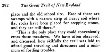
I first learned of this structure from a series of videos about the Old Connecticut Path, taken by Jason Newton, where he found and videoed sections of the path. One of these showed this structure and the river crossing. He speculated that this structure may have been built to carry the path through the marshy area at this location. He cited a book from 1940, "The Great Trail of New England," that was a historical reference on the path. The book compiled information from many sources, including diaries and journals from the past. He said there was a section from a journal written by an ancestor of some of the earliest settlers describing the path as he remembered it in the early twentieth century. One paragraph said that flat stones built up the path through a low-lying marshy area.
I knew that I had to see the structure for myself. Click here if you want to see the first video, as I will not include the same pictures of the structure here. The structure consists of one long wall going in an east/west direction. At each end are walls connecting at a 90-degree angle going in a southerly direction. (You will see all this in the accompanying video.) The north end wall appears to have been started but not completed. All three sections are the same width and construction. Although the wall is wide enough and flat enough to have been used as a road, it certainly wouldn't have been a smooth ride. In addition, there was no way to mount the wall without physically climbing it.. The north end has a downward slope, but I believe this is from a collapse.
I also explored the area on all sides of the structure and found no evidence of a well-used trail, certainly not one that would have carried horses, carts, and wagons. If you read the book I mentioned above, you will learn this was a very popular path (road). If this structure was used for the road, the two connecting walls wouldn't have been a part of it, and there would not have been sharp, 90-degree angles. If you read the description of the wall (excerpt above) it does not say this was a massive pile of stones. It only mentions some "flat rocks...used as stepping stones".
I continued my exploration and did find the old path where it crossed the Mt. Hope river. It was obvious this was an old, heavily travelled road.
 |
| Northside Crossing |
 |
| Southside Crossing |
Now, this opens up another mystery: What is it?


.JPG)

No comments:
Post a Comment
Your comments are always welcome. Please keep them clean or they will be deleted.